Navigation on board Tikina
Since the beginning of time, man has had the need to navigate.
We progressed from using land marks and drawing lines on the ground to using the stars and portable maps on paper.
Today, many mariners make use of the Navstar
system set up by the United States Department of Defense.
We use this by means of a GPS.
These a much cheaper now, and almost every vessel has a GPS on board. Also much cheaper now are laptops.
It is now possible to purchase a GPS unit and a 2nd hand laptop for the price of an inexpensive chartplotter.
Now comes the problem – what software to use!
Of the many versions of PC navigation software in use today, I chose to use SoftwareOnBoard from DigiBOAT
| It is: | • Inexpensive ($40.00 AUD) |
| • Uses C-Maps (the industry standard | |
| • Made in Australia |
Installation is as simple as unzipping the files to your selected directory and double clicking SOB.exe to run
the program.
There is no risk of SOB leaving remnants of itself behind if you wish to uninstall it. (Why would you?)
If you are happy with the trial, request the
unlock code from DigiBOAT
Connecing to your laptop
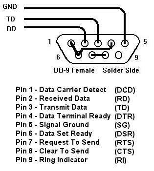
The NMEA data out wire from the GPS connects to the RD or pin 2 on the laptop serial connenctor.
The common or ground wire connects to SG or pin 5 of the connector.
TD or pin 3 of the connector is connected to the Autopilot.
Some PCs and laptops may still not be able to communicate with the GPS or autopilot. On my Sony laptop I had to use "NULL modem" connections to perform "handshaking". (See the diagram)
 |
If your computer has a 25 pin connector, here are the DB9 and DB25 pin assignments
|
Great! We now have our GPS talking to our PC.
Our location is shown on he map and the Ship's Data panel is showing the speed and direction.
Double clicking on the map brings upt the Raw NMEA Data window so the NMEA data from the GPS can be seen.
Waypoints
I also had many waypoints in a file on my PC that I wished tu use with "Software on Board".
This meant I had to find a way of converting this file to the format required by "sOb".
To this end I put together a small app, which I have enhanced an made available for public use.
It may not do all files, but you made find it useful.
Waypoint Importer details
Download WaypointImporter
There seems to be a standard getting greater prominence for the exchange of GPS data between software. This format
is known as GPX (GPs eXchange format).
Download GPX converter
If needed, download the VB6 support files
Home
Some GPS links
http://www.gpsinformation.net
Peter Bennett's GPS and NMEA Site
http://www.allgps.com/
Topografix for GPs eXchange format.